Severe thunderstorms are expected to batter south Arkansas Wednesday night into Thursday, according to the National Weather Service in Shreveport.
According to the NWS, showers and thunderstorms are expected to move into the region Wednesday evening and continue overnight until Thursday afternoon.
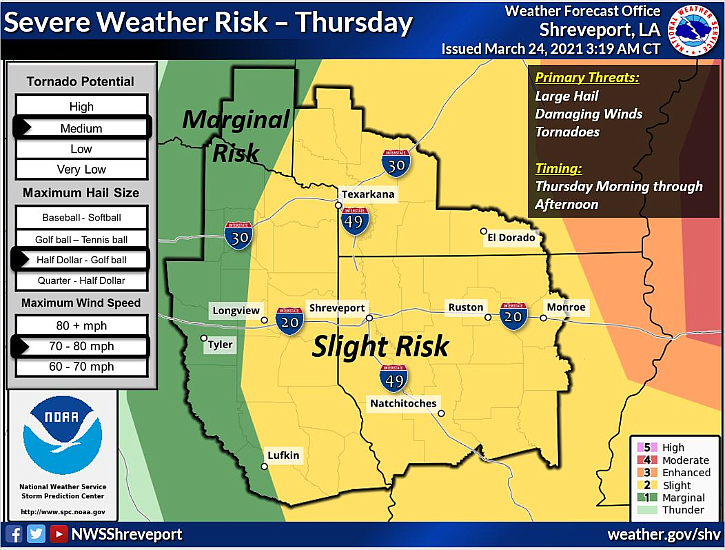
Southern Arkansas is one of the regions with the highest risk for severe storms both Wednesday night and Thursday.
The NWS Hazardous Weather Outlook states “the severe weather threat will continue into Thursday across the remainder of the region with the highest risk across North Louisiana and Southern Arkansas. Large hail and damaging winds will be possible through Thursday afternoon, but an isolated tornado or two can’t be ruled out.”
NWS forecaster Shane Pendleton said the NWS is emphasizing that the storms could produce “half-dollar to golf ball sized hail and winds up to 60 to 70 miles per hour” and warned that residents should remain aware of the potential for a tornado.
“We do want to remind everyone to have their severe weather and tornado readiness preparation made [in advance] and to have ways of receiving severe weather alerts that will wake you up if it affects your area,” Pendleton said.
An NWS-issued flood warning was also in affect Wednesday afternoon for Ouachita River at Felsenthal Lock and Dam affecting Union and Ashley counties. This flood warning was issued at 10 a.m. on Wednesday by the NWS and was, as of Wednesday afternoon, set to expire at 11:45 a.m. on Thursday.
The warning states that “minor flooding is occurring and minor flooding is forecast” in that location.
More storms are expected on Saturday and Sunday, though those were not expected to produce severe weather as of Wednesday afternoon.