Union County is in for a wet weekend, and just in time for Severe Weather Awareness week, Jeff Hood, a meteorologist at the Little Rock National Weather Office, said Friday afternoon.
“We’re pretty confident that we’re going to get quite a bit more rain,” Hood said, referring to the storms that hit the area Thursday night. “It will be quite a heavy rainfall period.”
A persistent pattern of stormy weather is coming up from the southwest over Arkansas and surrounding states, Hood explained, causing the rainy weather.
“Whenever one of these systems comes through it kind of pulls all the moisture out of the air,” Hood said, which is part of the reason storms are expected to continue through Monday.
“Already across the area, we’ve gotten between 1.5 inches to 3 inches across southern Arkansas. By the time the rain starts to wind down Monday … we could see another 2 to 3 inches of rainfall. That could put you anywhere from about 3 inches to as much as 6 inches total from the Thursday to Monday timeframe,” Hood said.
The NWS isn’t predicting severe weather in the area, although forecasters will continue to watch the area in case anything develops. Hood said there is a possibility of thunderstorms Saturday night, but that weather is expected to miss southern Arkansas, hitting southern Oklahoma and northern Arkansas instead.
“Nothing really jumps out at us that says ‘severe weather threat’ going into next week,” Hood said.
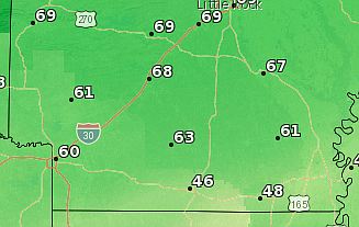
Hood said on Friday, the southern part of Arkansas was sitting at a “stalled front,” which caused the cool temperatures felt in Union County. Starting today, temperatures are expected to climb to highs in the 60s and 70s and lows in the upper 40s and 50s at night throughout the weekend.
On Monday, temperatures will drop again as another front approaches the area, Hood said. Highs are expected to be in the 50s and lows in the 40s, he said.
On Sunday, Severe Weather Awareness week will begin in Arkansas. The annual event serves as an opportunity for the NWS to provide public education on safety and preparedness during severe weather events, and also allows the agency to show Arkansans how they can help forecasters and their community by self-reporting weather conditions.
“We’ll talk about different types of severe weather every day, and if nothing else, it kind of gets people in the right mindset to be prepared, not be worried and to get a plan in place to get through these kinds of things,” Hood said. “We’ll also show some ways (Arkansans) can help us do our job better, by using social media and submitting storm reports if they’re able to safely do so. … The more information we can find out when severe weather is occurring … could help us warn folks the town over in a timely manner or let them know what hazards there are.”
While this weekend’s weather isn’t expected to be severe, Hood noted that should water levels rise to the point that any roadway a resident comes upon is flooded, they should always “turn around, don’t drown.”
“It sounds silly … but if you can’t see the roadway under a flooded river, flooded creek, flooded lake — whatever it is — then you don’t know what the condition of that roadbed or roadway is under the water,” Hood said.
He also suggested local residents think about the conditions caused by last week’s severe winter weather and the steps they took to be prepared for that, like stocking up on supplies.
“We need to think about emergency supply kits, making sure you have water and food on hand, batteries and medicine — things in place if you’re not able to get out and about,” he said.
While last week’s snow didn’t cause the rainfall forecast this weekend, Hood noted that it could still have an impact. As the snow has melted, water that wasn’t absorbed into the ground has run off into bodies of water, contributing to a rise in water levels in streams, creeks, rivers and other bodies of water, he said. That could affect potential flooding over the weekend.
“You introduce a couple of inches of rain to these bodies of water and that’s where we’re seeing some of these creeks and streams leaving their banks and the rivers’ water levels being higher,” Hood said.
According to the NWS forecast, rain could continue into Tuesday, but chances decrease after Monday. To learn more about severe weather, visit weather.gov.
