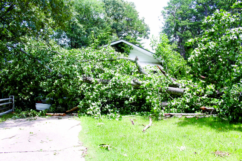
Eddie and Carolyn Yarbrough were in their living room around 8:30 Sunday night when a storm hit Union County. With winds of between 12 and 28 mph, according to the National Weather Service in Shreveport, Louisiana, multiple trees fell around the county including one of the trees outside of the Yarbrough house.
Eddie said the kind of tree that fell doesn't have very deep roots, which makes it easy for them to be blown over by slightly intense wind.
The tree fell just outside their home, barring the front door and landing on the car in their driveway.
"I think I'm in shock," Carolyn said.
Eddie said there was no warning before the storm or the tree falling. It mostly missed their home, which both said was good, all things considering.
"We're just very grateful because it could have been a lot worse," Eddie said. "If it had fallen on the house, we wouldn't have made it."
However, they were not the only ones impacted by the storms on Sunday night.
According to Entergy spokesman Christopher Wasson, by 7 p.m. on Sunday, the El Dorado/Camden area had just over 200 outages remaining. The next wave of storms resulted in 4,575 peak outages.
As of 8 a.m. on Monday, there were 3,898 outages. Damage assessment from the last wave of storms was ongoing.
As of Monday at 7 p.m., the El Dorado area had 921 outages. The Camden area has 59 outages. Most of the outages in the El Dorado/Camden area were expected to be repaired over night. Wasson said Entergy expects full restoration today.
Multiple rounds of storms with heavy rain and wind also kept crews from several city departments busy throughout the night and all day Monday.
Fire Chief Chad Mosby and Robert Edmonds, director of public works, said firefighters and street crews spent the night responding to emergency calls about downed trees, limbs and debris.
No major damage was reported. County Judge Mike Loftin said he had heard about trees falling and knew that the fire departments around the county were responding to them, but he did not have reports of any damage to the roads themselves.
“It was scattered around town. We had a couple of trees down on Mosby, Sunset Road and one, I think, on the north side of town,” Edmonds said.
Mosby said fire crews faced a similar situation, noting that firefighters responded to reports of trees and large limbs that had fallen on Block Street.
West Block between Newton and Flenniken was still closed to traffic late Monday morning due to a fallen tree.
Edmonds said emergency calls began coming in at approximately 8:30 p.m. Sunday and started to slow down at 3 a.m. Monday.
“They’re still out cleaning up. They couldn’t get it all cleaned up last night because there were power lines down in a lot of those areas,” Edmonds said.
He said there were no reports of issues with heavy flooding, which arose during heavy storms in April.
Edmonds noted that flash flooding typically occurs in city streets during heavy rains.
However in April, the flooding was more excessive as several city streets and residential lawns were buried underwater when the city’s storm-water system was overloaded by heavy rainfall, causing manhole covers to pop open and rendering some city streets impassable.
John Peppers, treatment superintendent for the El Dorado Water Utilities, said power outages that were caused by Sunday night’s storms temporarily shut down several EWU facilities, including the south wastewater treatment plant on South Jackson, the Hoover elevated water tank on East Beech and the Mount Holly wells and pump station.
The Mount Holly facilities were back up and running by 4 p.m. Monday.
Peppers said controls for the Hoover tank were swapped to the elevated water tank on Elm Street.
Power for the Hoover tank and south WWTP was expected to be restored by Monday evening, Peppers said.
According to the Weather Service, more scattered showers and thunderstorms are expected to develop starting midday Tuesday. Locally heavy rainfall and strong gusty winds possible in stronger storms. For the remainder of the week, daytime heating will lead to isolated to possible scattered showers and thunderstorms to form, mainly in the afternoon and evening each day, through next weekend. Some of the stronger storms may produce locally gusty winds and brief, heavy rainfall while localized flash flooding will be possible with slower moving storms through this period.
Tia Lyons may be contacted at 870-862-6611 or [email protected].
Michael Shine may be contacted at 870-862-6611 or [email protected].